Our earth is turning into a water world. scientist.ponmudi
Chapter -
One The story of the plate tectonic theory.
The development of the plate tectonic theory from the continental drift theory. (People who are familiar with the theory can directly go to the second chapter) The fossils of a land lived animal called as ''mesosaurus'' was found on the South American continent as well as on the African continent which has been separated by the wide Atlantic Ocean.(fig-1)
 on this findings Dr.Alfred wegener a meteorologist from German,argued that a land dwelled animal definitely can cross the wide ocean therefore the presence of the fossils of mesosaurus on the South American and the African continent indicate that the two continents were once joined with each other and later separated and moved to the present position. Further to state,Wegener altered the world map by setting the regions adjacently where the fossils of plants and animals, which could have grown or lived similar climate condition, were discovered.(fig-2)
 On the basis, he hypothesized that two hundred and fifty million years ago, all the continents were joined together as one single continent, which he called “Pangaea”. Wegener stated that one hundred and fifty million years ago, this super continent broke down to form two huge continents called Laurasia and Gondwana and these two continents started to drift in the opposite directions of north and south respectively. (fig-3)
 Wegener stated that later, around 100 million years ago, the northern continent again split into two and two continents of North America and Europe were formed. These two continents drifted in the opposite directions of west and east respectively. Wegener also said that similarly, Southern continent also disintegrated into many parts and led to the formation of South America, which started to drift towards north-western direction, reaching the current location only three million years ago.(fig-4)
 Similarly Wegener hypothesized that the African Continent which was separated from the Southern Continent, drifted towards north-eastern direction, collided with the southern part of the European Continent, giving rise to the formation of the Alps Mountain Range. Likewise, Wegener also hypothesized that the Indian land area too was separated from the remnants of the Gondwana i.e. Antarctic Continent, drifted towards north-eastern direction and collided with the southern part of the Asian Continent, which gave rise to the formation of the Everest Mountain Range.
This theory is called “The Continental Drift”.
000000000000000000000 But, no evidence was found on the ocean floor for the drifting of continents by breaking the ocean floor. During the Second World War, Dr. Harry Hess, a professor of Geology, who worked for the American Navy prepared a chart on the uneven surfaces of the ocean floor through a sonar instrument. Incidentally, he discovered under-water volcanic ranges for thousands of kilometers between and around the continents.(fig-5)
Similarly Wegener hypothesized that the African Continent which was separated from the Southern Continent, drifted towards north-eastern direction, collided with the southern part of the European Continent, giving rise to the formation of the Alps Mountain Range. Likewise, Wegener also hypothesized that the Indian land area too was separated from the remnants of the Gondwana i.e. Antarctic Continent, drifted towards north-eastern direction and collided with the southern part of the Asian Continent, which gave rise to the formation of the Everest Mountain Range.
This theory is called “The Continental Drift”.
000000000000000000000 But, no evidence was found on the ocean floor for the drifting of continents by breaking the ocean floor. During the Second World War, Dr. Harry Hess, a professor of Geology, who worked for the American Navy prepared a chart on the uneven surfaces of the ocean floor through a sonar instrument. Incidentally, he discovered under-water volcanic ranges for thousands of kilometers between and around the continents.(fig-5)
 Based on this finding, Harry came up with a new theory. He says that hot magma coming out of these volcanic ranges from below the earth, solidifies into new ocean floors and these ocean floors drift in opposite directions. So, the continents also drift in opposite directions along with these ocean floors.(fig-6,7)

 This theory is called, “The Plate Tectonic Theory”.
According to this trheory, two hundred and fifty million years ago, prior to breaking up and drifting to their present locations, all the seven continents had at one time formed a single supercontinent which was called Pangaea. The geologists also believed that this supercontinent was surrounded by a shallow sea area.
The geologists believed that later, hot magma from beneath the Pangaea supercontinent gushed to the top, cooled and solidified and this magma went back into the earth due to its increase in weight. They also believed that this magma, which was found thousands of kilometers under the earth, rotated like wheels in the opposite directions and caused the supercontinent above to break up into two.
The geologists also believed that this led to the formation of two large continents namely Laurasia and Gondwana a hundred and eighty million years ago, of which Laurasia drifted towards the northern region and the continent of Gondwana drifted towards the southern region.
The geologists believe that an ocean area called Tethys formed between these continents, i.e., in the equatorial region. The geologists also believe that eighty million years ago, the continent of Laurasia also split into two, leading to the creation of the continents of North America and Eurasia, which moved in the opposite directions of west and east respectively.
They also believed that as a result of the above, the North Atlantic Ocean region was formed between these two continents. The geologists also believe that in a similar way, after the split of the southern region of the continent of Gondwana into many parts, these continents drifted towards the north.
Further, they also believed that particularly, due to the split in the western part of the continent of Gondwana, the continents of South America and Africa were formed and due to their respective drift towards north-west and north-east directions, the South Atlantic ocean region emerged between these two continents.
The geologists believed that the South American Continent, which was drifting towards north-west, reached its current location only three million years ago.
In the same way, the geologists believe that the Alps mountain range came into being due to the thrusting of the land region between the African and Eurasian Continents caused by the collision of the African Continent which was said to be drifting towards north-west, with the southern part of the European Continent.
The geologists also believe that in a similar way, India and Australia also broke away from the Continent of Antarctica and drifted in the north-eastern direction.
The geologists believe that due to the collision of the Indian land area with the southern part of the Asian Continent fifty million years ago, Himalayan mountain range rose between these two continents by thrusting.
The geologists believe that even today, the magma under the earth becomes solid after reaching the surface, forming a new seafloor in the volcanic range under the sea that extends in the north-south direction, and is drifting in the opposite directions causing the continents on both sides of the Atlantic Ocean also to drift apart in the opposite directions along with the ocean floor.
The geologists are also of the opinion that when the continents drift separately along with the ocean floor, friction is caused between their edges and earthquakes are caused.
chapter two
But Geologists fail to give explanations for the earthquakes and the tsunamis which formed on the islands of Sumatra and Haiti on the basis of the plate tectonic theory.
Similarly Geologists fail to give explanation for the discovery of seventy million year old dinosaur fossils in the Arctic Circle.
At this point, the geologists of NASA, the leading scientific research center of America, prepared a graphical representation of the places world-wide where a total of 3,58,214 earthquakes occurred during the past 35 years from the year 1963 to 1998.(fig-8)
This theory is called, “The Plate Tectonic Theory”.
According to this trheory, two hundred and fifty million years ago, prior to breaking up and drifting to their present locations, all the seven continents had at one time formed a single supercontinent which was called Pangaea. The geologists also believed that this supercontinent was surrounded by a shallow sea area.
The geologists believed that later, hot magma from beneath the Pangaea supercontinent gushed to the top, cooled and solidified and this magma went back into the earth due to its increase in weight. They also believed that this magma, which was found thousands of kilometers under the earth, rotated like wheels in the opposite directions and caused the supercontinent above to break up into two.
The geologists also believed that this led to the formation of two large continents namely Laurasia and Gondwana a hundred and eighty million years ago, of which Laurasia drifted towards the northern region and the continent of Gondwana drifted towards the southern region.
The geologists believe that an ocean area called Tethys formed between these continents, i.e., in the equatorial region. The geologists also believe that eighty million years ago, the continent of Laurasia also split into two, leading to the creation of the continents of North America and Eurasia, which moved in the opposite directions of west and east respectively.
They also believed that as a result of the above, the North Atlantic Ocean region was formed between these two continents. The geologists also believe that in a similar way, after the split of the southern region of the continent of Gondwana into many parts, these continents drifted towards the north.
Further, they also believed that particularly, due to the split in the western part of the continent of Gondwana, the continents of South America and Africa were formed and due to their respective drift towards north-west and north-east directions, the South Atlantic ocean region emerged between these two continents.
The geologists believed that the South American Continent, which was drifting towards north-west, reached its current location only three million years ago.
In the same way, the geologists believe that the Alps mountain range came into being due to the thrusting of the land region between the African and Eurasian Continents caused by the collision of the African Continent which was said to be drifting towards north-west, with the southern part of the European Continent.
The geologists also believe that in a similar way, India and Australia also broke away from the Continent of Antarctica and drifted in the north-eastern direction.
The geologists believe that due to the collision of the Indian land area with the southern part of the Asian Continent fifty million years ago, Himalayan mountain range rose between these two continents by thrusting.
The geologists believe that even today, the magma under the earth becomes solid after reaching the surface, forming a new seafloor in the volcanic range under the sea that extends in the north-south direction, and is drifting in the opposite directions causing the continents on both sides of the Atlantic Ocean also to drift apart in the opposite directions along with the ocean floor.
The geologists are also of the opinion that when the continents drift separately along with the ocean floor, friction is caused between their edges and earthquakes are caused.
chapter two
But Geologists fail to give explanations for the earthquakes and the tsunamis which formed on the islands of Sumatra and Haiti on the basis of the plate tectonic theory.
Similarly Geologists fail to give explanation for the discovery of seventy million year old dinosaur fossils in the Arctic Circle.
At this point, the geologists of NASA, the leading scientific research center of America, prepared a graphical representation of the places world-wide where a total of 3,58,214 earthquakes occurred during the past 35 years from the year 1963 to 1998.(fig-8)
 In that global level graph on earthquakes had not recorded any continuous earthquakes in the ocean region between the Indian and the Australian continents. Thus, on the basis of non-occurrence of a series of earthquakes in the ocean region between the continents of India and Australia, it is proved with concrete evidence that the ocean floor between these two continents is continuous and the ocean floor and the continents between these two continents are stationary. At this juncture, NASA released a chart stating it as an illustration of the movement of the continental plates.(fig-9,)
 Even in that chart, it has been stated that they are still unsure as to what is actually happening in the ocean floor region between the continents of India and Australia.(fig-10)
 Moreover, they have offered contradictory explanations for the tsunami that rocked the entire South Asia on 26.12.2004. Particularly, in the report released by NASA on 10.3.2005, Dr. Richard Cross and Dr. Benjamin Bang Cho have explained that the earthquake and tsunami were caused only due to the sudden drifting of the ocean floor of the Indian Continent under the Indonesian Islands.(fig11)
 But, in the report released by NASA after three months, i.e., on 27.4.2005, the geologists of NASA had stated that the earthquake and tsunami were caused only due to the sudden drifting of the ocean floor of the Australian Continent under the Indonesian Islands.(fig12)
 Thus, it is proved beyond doubt that the geologists of NASA have offered an imaginary explanation for the earthquake and tsunami on the basis of a mere hunch, without knowing what was actually happening in the ocean floor area between the two continents. Therefore the question raised hears is what is the reason for the earthquakes and the tsunamis?
Similarly, what is the reason for the presence of the dinosaurs fossils on the island continents such as Antarctica and the Australia.
The Sumatra Island of Indonesia experienced a tsunami due to the earthquake that occurred under the ocean on 26.12.2004.
After the earthquake, the northern region of Simeulue Island, situated near the Island of Sumatra, had risen up to 4 feet from the sea level. This had made visible the flora submerged under the sea in that area. Under similar conditions, when an earthquake shook the central part of the same simeulue Island on 20.02.2008, a satellite that recorded the ground level variations had captured pictures of rings with lots of ups and downs of a fifty one centimeter high, formed around the epicenter of the earthquake that occurred in the simeulue island, in a circumference extending to many kilometers.(fig13)
Thus, it is proved beyond doubt that the geologists of NASA have offered an imaginary explanation for the earthquake and tsunami on the basis of a mere hunch, without knowing what was actually happening in the ocean floor area between the two continents. Therefore the question raised hears is what is the reason for the earthquakes and the tsunamis?
Similarly, what is the reason for the presence of the dinosaurs fossils on the island continents such as Antarctica and the Australia.
The Sumatra Island of Indonesia experienced a tsunami due to the earthquake that occurred under the ocean on 26.12.2004.
After the earthquake, the northern region of Simeulue Island, situated near the Island of Sumatra, had risen up to 4 feet from the sea level. This had made visible the flora submerged under the sea in that area. Under similar conditions, when an earthquake shook the central part of the same simeulue Island on 20.02.2008, a satellite that recorded the ground level variations had captured pictures of rings with lots of ups and downs of a fifty one centimeter high, formed around the epicenter of the earthquake that occurred in the simeulue island, in a circumference extending to many kilometers.(fig13)
 Similar surface deformation has been formed around the volcano due to the volcanic activity When a research team headed by Dr. Juliet Biggs, a seismologist of Miami University studied four volcanoes in the eastern region of Africa through a satellite that recorded the ground level variations by using radio waves, it was found that rugged rings of a few centimeter heights had formed around these volcanoes in a circumference extending to many kilometers. (fig-14)
 volcanologist,stated that the upward and downward movement of the volcano as the reason for the formation of these rugged structures around the volcano. Particularly, when a volcano rises due to the accumulation of magma underneath, the ground that surrounds the volcano also tends to rise a few centimeters along with the volcano.
Similarly, when the volcano settles down after the gases and steam are expelled, the land area that had risen along with it in a circular form also settles down and this causes rings of scar-like ups and downs around the volcano.
Hence, it was proved with evidence that the South Asian tsunami was caused only by the eruption of a volcano below the surface of the earth. During the same period, in 2009 when a severe earthquake occurred in L’Aquila situated in the central Italy, the satellite that recorded the ground level variations, captured the rings of ups and downs with a height and depth of a few centimeters that were similar to those formed around the epicenter of the earthquake extending to a circumference of several kilometers.(fig15)
volcanologist,stated that the upward and downward movement of the volcano as the reason for the formation of these rugged structures around the volcano. Particularly, when a volcano rises due to the accumulation of magma underneath, the ground that surrounds the volcano also tends to rise a few centimeters along with the volcano.
Similarly, when the volcano settles down after the gases and steam are expelled, the land area that had risen along with it in a circular form also settles down and this causes rings of scar-like ups and downs around the volcano.
Hence, it was proved with evidence that the South Asian tsunami was caused only by the eruption of a volcano below the surface of the earth. During the same period, in 2009 when a severe earthquake occurred in L’Aquila situated in the central Italy, the satellite that recorded the ground level variations, captured the rings of ups and downs with a height and depth of a few centimeters that were similar to those formed around the epicenter of the earthquake extending to a circumference of several kilometers.(fig15)
 Moreover, a scientist known as Giampaolo Giuliani who is engaged in a research for predicting earthquakes beforehand, had discovered the emission of a radioactive gas called Radon from below the earth in that earthquake region a week before the occurrence of the earthquake. Most importantly, Radon is a gas emitted by volcanoes.
Hence, it has been proved with evidence that the earthquake in L’Aquila was caused only by the volcanic eruption under the earth. Similarly, on 11.03.2011, a tsunami occurred due to the earthquake under the sea near the Japanese island Honshu.(fig16)
Moreover, a scientist known as Giampaolo Giuliani who is engaged in a research for predicting earthquakes beforehand, had discovered the emission of a radioactive gas called Radon from below the earth in that earthquake region a week before the occurrence of the earthquake. Most importantly, Radon is a gas emitted by volcanoes.
Hence, it has been proved with evidence that the earthquake in L’Aquila was caused only by the volcanic eruption under the earth. Similarly, on 11.03.2011, a tsunami occurred due to the earthquake under the sea near the Japanese island Honshu.(fig16)
 At that time, a satellite that recorded the ground level variations had captured pictures of rings with lots of ups and downs of a few centimeter height formed around the epicenter of the earthquake that occurred in the Honshu island, in a circumference extending to many kilometers.
It was also recorded in the pictures of the satellite that three days before the occurrence of the earthquake, the temperature of the upper layer of the atmosphere just above the epicenter region of the earthquake was abnormally high.(fig17)
At that time, a satellite that recorded the ground level variations had captured pictures of rings with lots of ups and downs of a few centimeter height formed around the epicenter of the earthquake that occurred in the Honshu island, in a circumference extending to many kilometers.
It was also recorded in the pictures of the satellite that three days before the occurrence of the earthquake, the temperature of the upper layer of the atmosphere just above the epicenter region of the earthquake was abnormally high.(fig17)
 A scientist of NASA study centre, Dimitar Ouzounov had stated that this may be due to the emission of Radon gas in that area from beneath the earth which has radioactive properties. Dimitar Ouzounov had explained that electrons were released from the molecules found in the air due to radiation caused by the Radon gas and these electrons must have condensed to form an electron cloud.
As the ions formed out of this had the tendency to absorb water and this reaction is a heat emitting reaction, it might have caused the temperature of the upper layer of the atmosphere to rise abnormally. Moreover, it was also recorded in the pictures of the satellite that after the earthquake, the temperature of the top layer of atmosphere in the Honshu island had returned to its normal level. Hence, there is evidential proof that the earthquake and tsunami in Honshu island were caused only by the eruption of a volcano below the surface of the earth.
Similarly, when an earthquake and tsunami rocked the Haiti Island on 12.01.2010, a satellite that recorded the ground level variations had captured pictures of rings with lots of ups and downs of a few centimeter height formed around the centre of the earthquake that occurred in the Haiti island, in a circumference extending to many kilometres . After the earthquake, the seashore of Haiti Island had risen above sea level. This made the sea flora in that region clearly visible.(fig18)
A scientist of NASA study centre, Dimitar Ouzounov had stated that this may be due to the emission of Radon gas in that area from beneath the earth which has radioactive properties. Dimitar Ouzounov had explained that electrons were released from the molecules found in the air due to radiation caused by the Radon gas and these electrons must have condensed to form an electron cloud.
As the ions formed out of this had the tendency to absorb water and this reaction is a heat emitting reaction, it might have caused the temperature of the upper layer of the atmosphere to rise abnormally. Moreover, it was also recorded in the pictures of the satellite that after the earthquake, the temperature of the top layer of atmosphere in the Honshu island had returned to its normal level. Hence, there is evidential proof that the earthquake and tsunami in Honshu island were caused only by the eruption of a volcano below the surface of the earth.
Similarly, when an earthquake and tsunami rocked the Haiti Island on 12.01.2010, a satellite that recorded the ground level variations had captured pictures of rings with lots of ups and downs of a few centimeter height formed around the centre of the earthquake that occurred in the Haiti island, in a circumference extending to many kilometres . After the earthquake, the seashore of Haiti Island had risen above sea level. This made the sea flora in that region clearly visible.(fig18)
 So, it was proved with evidence that the earthquake and tsunami in Haiti island were caused only by the eruption and uplift of a volcano below the surface of the earth. Hence, it was proved with evidence that the sea floor is a continous formation and the continents are fixed formation and the earthquakes and the tsunami was caused only by the eruption of a volcano below the surface of the earth.
My discovery has been supported by other evidence.
The seafloor is a continuous formation and the continents are fixed formation. In the global level graph on earthquakes had not recorded any continuous earthquakes in the ocean region between the North American continent formed in the central part of the Atlantic Ocean and drifting towards north with the ocean floor believed to be drifting towards north and the South American continent formed in the central part of the Atlantic Ocean and drifting towards north-west with the ocean floor believed to be drifting towards north-west.(fig-19)
So, it was proved with evidence that the earthquake and tsunami in Haiti island were caused only by the eruption and uplift of a volcano below the surface of the earth. Hence, it was proved with evidence that the sea floor is a continous formation and the continents are fixed formation and the earthquakes and the tsunami was caused only by the eruption of a volcano below the surface of the earth.
My discovery has been supported by other evidence.
The seafloor is a continuous formation and the continents are fixed formation. In the global level graph on earthquakes had not recorded any continuous earthquakes in the ocean region between the North American continent formed in the central part of the Atlantic Ocean and drifting towards north with the ocean floor believed to be drifting towards north and the South American continent formed in the central part of the Atlantic Ocean and drifting towards north-west with the ocean floor believed to be drifting towards north-west.(fig-19)
 Hence, on the basis of the absence of continuous earthquakes in the ocean floor area between the North American and South American continents, it has been proved with concrete evidence that the ocean floor between these two continents is continuous and the ocean floor between these two continents as well as the North American and South American continents are stationary. Geologist named the region as ''undefined boundary''(fig-20)
 Evidence - two The saint peter and saint Paul islands of the mid ocean ridge rock age is estimated to be 4.5 billion years old. Similarly the new seafloor is believed to be formed continuously and spreading in the opposite direction all along the mid Atlantic ridge. If that is the case, then the age of the rock in the mid Atlantic ridge must be younger than the rock near the edge of the continents. But contrary to the expectation, the rocks found on the islands, which is called as saint peter rock and the Saint Paul rock which is formed in the mid Atlantic ridge dated 4.5 billion years old.(fig-21)
 This proved that the seafloor spreading hypothesis is just a misconception. This also proved that the seafloor is a fixed formation, from the formation of the earth.
Evidence -
Three Paleodictyon fossils have been discovered at the bottom of the mid ocean ridge.
similarly,the fossils of the sea animal called as the paleodictyon which lived from the cambrian to the eocene has been discovered from the mid ocean ridge region which is lying 15,000 feet below the sea level.the discovery was made by researchers used by the ALVIN submarine vehicle.(fig-22)
This proved that the seafloor spreading hypothesis is just a misconception. This also proved that the seafloor is a fixed formation, from the formation of the earth.
Evidence -
Three Paleodictyon fossils have been discovered at the bottom of the mid ocean ridge.
similarly,the fossils of the sea animal called as the paleodictyon which lived from the cambrian to the eocene has been discovered from the mid ocean ridge region which is lying 15,000 feet below the sea level.the discovery was made by researchers used by the ALVIN submarine vehicle.(fig-22)
 This evidence also proved that there is no sea floor spreading in the mid Atlantic region. and all this evidence clearly proved beyond doubt that the seafloor and the continents were fixed formation 000000000000000000000000 Similarly, it is proved with evidence that the geologists of the American Geological Association, which is known as USGS, had offered a baseless and fictitious explanation when an earthquake and tsunami rocked Haiti, an island situated in the Caribbean group of islands on 12.01.2010.
Particularly, the Continent of North America, formed in the central part of the Atlantic Ocean is believed to be moving towards west along with the ocean floor which is supposed to be drifting towards west. In the same way, the Continent of South America, formed in the central part of the Atlantic Ocean is believed to be moving towards north-west along with the ocean floor which is north-west to be drifting towards north-west.
Under these circumstances, a question arises as to how exactly the Caribbean group of islands, which is located between these two continents, was formed. Some geologists believe that the Caribbean group of islands would have formed due to volcanic activity in the Pacific Ocean region a hundred million years ago, particularly at the place where the Galapagos group of islands is situated now, and later the Caribbean group of islands formed into a separate tectonic plate and started moving towards east.
Under these circumstances, some geologists believe that the American Continents moved separately in opposite directions towards west and during that period, the bridge-like Central American land area had not formed between the continents. On account of this, a gap existed between these continents and the Caribbean tectonic plate entered into this gap. Later, the Central American land area rose from under the sea and this created a land connection between the continents. According to this theory called “The Pacific Model”, it is believed that the Caribbean group of islands might be moving towards the east.(fig23,24)
This evidence also proved that there is no sea floor spreading in the mid Atlantic region. and all this evidence clearly proved beyond doubt that the seafloor and the continents were fixed formation 000000000000000000000000 Similarly, it is proved with evidence that the geologists of the American Geological Association, which is known as USGS, had offered a baseless and fictitious explanation when an earthquake and tsunami rocked Haiti, an island situated in the Caribbean group of islands on 12.01.2010.
Particularly, the Continent of North America, formed in the central part of the Atlantic Ocean is believed to be moving towards west along with the ocean floor which is supposed to be drifting towards west. In the same way, the Continent of South America, formed in the central part of the Atlantic Ocean is believed to be moving towards north-west along with the ocean floor which is north-west to be drifting towards north-west.
Under these circumstances, a question arises as to how exactly the Caribbean group of islands, which is located between these two continents, was formed. Some geologists believe that the Caribbean group of islands would have formed due to volcanic activity in the Pacific Ocean region a hundred million years ago, particularly at the place where the Galapagos group of islands is situated now, and later the Caribbean group of islands formed into a separate tectonic plate and started moving towards east.
Under these circumstances, some geologists believe that the American Continents moved separately in opposite directions towards west and during that period, the bridge-like Central American land area had not formed between the continents. On account of this, a gap existed between these continents and the Caribbean tectonic plate entered into this gap. Later, the Central American land area rose from under the sea and this created a land connection between the continents. According to this theory called “The Pacific Model”, it is believed that the Caribbean group of islands might be moving towards the east.(fig23,24)

 Particularly, in the eastern region of the Caribbean group of islands, volcanic mountain ranges have formed towards the north-south direction. As per the “The Pacific Model”, an explanation is offered for the formation of volcanic mountain ranges towards the north-south direction in the eastern region of the Caribbean group of islands.
It says that, when the Caribbean group of islands was moving in the easterly direction, the Atlantic Ocean floor heading towards the west went under the tectonic plate, melted due to the extremely high temperature and the magma thus formed rose up penetrating through the ocean floor and became volcanic mountains above the ocean floor.
Further, the geologists also believe that, ninety million years ago, the bridge-like continuous Central American land area had not formed between the American continents. During that period, a gap existed between these continents and the Caribbean tectonic plate entering into this gap has been the reason for their present location.
However, in 1971, Gregory S Horni and Bruce Simonson have discovered in the mountainous region of Nicaragua which is situated at the Central American land area, the bones of a dinosaur called Ornithopod that lived ninety to a hundred and twenty million years ago during the mid-cretaceous era.
Geologist Professor Joan Ostram of Yale University, after examining the bones of the dinosaur, has identified and confirmed that these bones, now kept in the Washington Museum, belong to a dinosaur called Ornithopod. This has proved with evidence that the land region of Central America situated between the American Continents was continuous even before ninety million years and the dinosaurs were migrating between the American Continents through this region.
In the same way, Manuel Ilduraldy Vincent and Zulma Gasparini, paleontologists of the Cuban Museum has discovered the bone fossils of a herbivore dinosaur that lived during the cretaceous era, i.e., a hundred and fifty million years ago, in the Organos mountain range located in the western part of Cuban Island of the Caribbean group of islands that are formed in a range between the American Continents.(fig-25)
Particularly, in the eastern region of the Caribbean group of islands, volcanic mountain ranges have formed towards the north-south direction. As per the “The Pacific Model”, an explanation is offered for the formation of volcanic mountain ranges towards the north-south direction in the eastern region of the Caribbean group of islands.
It says that, when the Caribbean group of islands was moving in the easterly direction, the Atlantic Ocean floor heading towards the west went under the tectonic plate, melted due to the extremely high temperature and the magma thus formed rose up penetrating through the ocean floor and became volcanic mountains above the ocean floor.
Further, the geologists also believe that, ninety million years ago, the bridge-like continuous Central American land area had not formed between the American continents. During that period, a gap existed between these continents and the Caribbean tectonic plate entering into this gap has been the reason for their present location.
However, in 1971, Gregory S Horni and Bruce Simonson have discovered in the mountainous region of Nicaragua which is situated at the Central American land area, the bones of a dinosaur called Ornithopod that lived ninety to a hundred and twenty million years ago during the mid-cretaceous era.
Geologist Professor Joan Ostram of Yale University, after examining the bones of the dinosaur, has identified and confirmed that these bones, now kept in the Washington Museum, belong to a dinosaur called Ornithopod. This has proved with evidence that the land region of Central America situated between the American Continents was continuous even before ninety million years and the dinosaurs were migrating between the American Continents through this region.
In the same way, Manuel Ilduraldy Vincent and Zulma Gasparini, paleontologists of the Cuban Museum has discovered the bone fossils of a herbivore dinosaur that lived during the cretaceous era, i.e., a hundred and fifty million years ago, in the Organos mountain range located in the western part of Cuban Island of the Caribbean group of islands that are formed in a range between the American Continents.(fig-25)
 Through this, it has been proved beyond doubt that as the sea level was low a hundred and fifty million years ago, the American Continents and the Caribbean group of islands had land connections and the dinosaurs were migrating through that region.
As a result, it has been proved with evidence that the explanations offered by the geologists saying that ninety million years ago, a gap existed between the American continents and the Caribbean tectonic plate entered through it were baseless and imaginary theories. At this point, some other geologists have a notion that the Caribbean group of Islands might have formed in the Atlantic Ocean region itself and moving in the western direction, they might have reached the current location. This theory is called “The Atlantic Model”.
But, there is no evidence for the presence of a significant number of volcanic mountains in the Atlantic Ocean region similar to those present in the Galapagos group of islands in the Pacific Ocean region. So, the geologists in favor of “The Atlantic Model” could not explain where exactly in the Atlantic Ocean region did the Caribbean group of Islands form. Hence, the geologists who support the Atlantic Model believe that the volcanic eruptions responsible for the formation of the Caribbean group of Islands might have disappeared over time.
However, the geologists who believe in the theory of “The Atlantic Model” are unable to explain how the volcanic mountain ranges in the eastern part of the Caribbean islands facing the north-south direction came into being. Under these circumstances, a few other geologists have offered a new theory that the Caribbean group of islands might be an in situ model. Hence, it boils down to the fact that the geologists, who state that the Caribbean group of islands is drifting as a tectonic plate, have no idea as to where the Caribbean group of islands was formed and in which direction it is heading.(fig-26)
Through this, it has been proved beyond doubt that as the sea level was low a hundred and fifty million years ago, the American Continents and the Caribbean group of islands had land connections and the dinosaurs were migrating through that region.
As a result, it has been proved with evidence that the explanations offered by the geologists saying that ninety million years ago, a gap existed between the American continents and the Caribbean tectonic plate entered through it were baseless and imaginary theories. At this point, some other geologists have a notion that the Caribbean group of Islands might have formed in the Atlantic Ocean region itself and moving in the western direction, they might have reached the current location. This theory is called “The Atlantic Model”.
But, there is no evidence for the presence of a significant number of volcanic mountains in the Atlantic Ocean region similar to those present in the Galapagos group of islands in the Pacific Ocean region. So, the geologists in favor of “The Atlantic Model” could not explain where exactly in the Atlantic Ocean region did the Caribbean group of Islands form. Hence, the geologists who support the Atlantic Model believe that the volcanic eruptions responsible for the formation of the Caribbean group of Islands might have disappeared over time.
However, the geologists who believe in the theory of “The Atlantic Model” are unable to explain how the volcanic mountain ranges in the eastern part of the Caribbean islands facing the north-south direction came into being. Under these circumstances, a few other geologists have offered a new theory that the Caribbean group of islands might be an in situ model. Hence, it boils down to the fact that the geologists, who state that the Caribbean group of islands is drifting as a tectonic plate, have no idea as to where the Caribbean group of islands was formed and in which direction it is heading.(fig-26)
 At this juncture, the geologists of the American Geological Association, which is known as USGS, had offered a baseless explanation for the earthquake and tsunami which rocked Haiti, an island situated in the Caribbean group of islands on 12.01.2010 that the earthquake in Haiti was caused only by the friction between the tectonic plates during the movement of the American and Caribbean tectonic plates.(fig-27)
 Specifically, the geologists of the American Geological Association, which is known as USGS, believe that the Caribbean group of islands is drifting as a tectonic plate, but since the geologists of the USGS Association do not know where the Caribbean tectonic plate was formed and in which direction it is heading, they avoid any direct mention of where the Caribbean tectonic plate is heading and state that the North American Continent is drifting towards west and on account of this movement, the Caribbean tectonic plate is moving towards east with respect to the North American Continent.
The geologists of the USGS organization explain that this caused friction between the tectonic plates resulting in the occurrence of earthquake and tsunami in the Island of Haiti. How can this be a correct and acceptable explanation?
In fact, it is a truth that the geologists of the USGS organization are not aware of what is happening in the ocean floor region between the American Continents. To conceal their ignorance, the geologists of the USGS organization have given an ambiguous explanation regarding the direction in which the Caribbean tectonic plate is drifting, thereby tactfully avoiding a direct reply.
This has brought to limelight that the geologists of the USGS organization are ignorant of the reason for the occurrence of earthquake and tsunami in the Island of Haiti.
The fact, it has been proved with evidence through a global seismograph, that the ocean floor and the continents are stationary and the ocean floor region between the continents is continuous. Also, the fact that the earthquake and tsunamis were caused only by volcanic eruptions below the surface of the earth, has been discovered through the images captured by a satellite.
Arctic dinosaur's mysteries.
If the continents are fixed formation then what is the reason for the presence of the dinosaur’s fossils in the island continents such as the Antarctica and the Australia.
Similarly what is the reason for the presence of the dinosaurus fossils in the Arctic Circle? The fossils of 200 million year old crocodiles and giant trees which are belong to tropical climate has been found in the Arizona, which is now in temperate climate zone also explained by the geologist on the basis of the plate tectonic theory.
The geologists believe that 200 million years ago Arizona was located near the equator region and later drifted to the current place. However, the geologists and zoologists who offer explanation about fossils on the basis of the Continental Drift Theory were also unable to explain the presence of the fossils of dinosaurs,which lived seventy million years ago, in the North Polar Region, specifically in the Alaska and in the northern parts of Siberia.
This is because as per the Continental Drift Theory, the geologists believe that Alaska and the northern parts of Siberia had moved into the Arctic Circle Region even before a hundred million years. But, now in Alaska and in the northern parts of Siberia, the annual average temperature is 20°C.But the eggs of reptiles need a temperature of 30°C to hatch.
And this raises the question as to how the dinosaurs which reproduced through eggs lived and reproduced in the Polar Regions? It is impossible for reptiles like dinosaurs to live and reproduce through eggs in the Polar Regions which are now snow covered. Hence, with the fossils of dinosaurs found in the Polar Regions, it has been categorically proved that during the era of dinosaurs, a temperature similar to the one found in the equatorial region must have prevailed in the Polar Regions also.
Similarly, due to the earth’s axial tilt of twenty three and a half degrees, the Polar Regions have a six month period of continuous daylight and nearly six months of night.
If night continues for a period of six months, in the absence of sunlight, plants cannot perform photosynthesis and survive.
Therefore geologist fail give explanation for the discovery of the arctic dinosaur's fossils on the basis of the plate tectonic theory.
The origin of the ocean
The ocean water came from deep earth Sea level rising is caused by the undersea hot springs. The city of Alexandria, in which the Egyptian queen Cleopatra lived, is now found at a depth of twenty feet below sea level!
Similarly, at the seashore of Mamallapuram near Chennai, the Pallavas constructed seven temples called Pagodas a thousand years ago. But, on the sea shore only one temple remains to be seen now. In the year 2004, during the tsunami when the sea receded, tourists and fishermen were able to see ruins for a distance of two kilometers. At present these ruins are found twenty feet below the sea. Near Norway,twenty million year old dinosaur fossils have been discovered on the seafloor which is lying two kilometers below the sea level.(fig-28)
Specifically, the geologists of the American Geological Association, which is known as USGS, believe that the Caribbean group of islands is drifting as a tectonic plate, but since the geologists of the USGS Association do not know where the Caribbean tectonic plate was formed and in which direction it is heading, they avoid any direct mention of where the Caribbean tectonic plate is heading and state that the North American Continent is drifting towards west and on account of this movement, the Caribbean tectonic plate is moving towards east with respect to the North American Continent.
The geologists of the USGS organization explain that this caused friction between the tectonic plates resulting in the occurrence of earthquake and tsunami in the Island of Haiti. How can this be a correct and acceptable explanation?
In fact, it is a truth that the geologists of the USGS organization are not aware of what is happening in the ocean floor region between the American Continents. To conceal their ignorance, the geologists of the USGS organization have given an ambiguous explanation regarding the direction in which the Caribbean tectonic plate is drifting, thereby tactfully avoiding a direct reply.
This has brought to limelight that the geologists of the USGS organization are ignorant of the reason for the occurrence of earthquake and tsunami in the Island of Haiti.
The fact, it has been proved with evidence through a global seismograph, that the ocean floor and the continents are stationary and the ocean floor region between the continents is continuous. Also, the fact that the earthquake and tsunamis were caused only by volcanic eruptions below the surface of the earth, has been discovered through the images captured by a satellite.
Arctic dinosaur's mysteries.
If the continents are fixed formation then what is the reason for the presence of the dinosaur’s fossils in the island continents such as the Antarctica and the Australia.
Similarly what is the reason for the presence of the dinosaurus fossils in the Arctic Circle? The fossils of 200 million year old crocodiles and giant trees which are belong to tropical climate has been found in the Arizona, which is now in temperate climate zone also explained by the geologist on the basis of the plate tectonic theory.
The geologists believe that 200 million years ago Arizona was located near the equator region and later drifted to the current place. However, the geologists and zoologists who offer explanation about fossils on the basis of the Continental Drift Theory were also unable to explain the presence of the fossils of dinosaurs,which lived seventy million years ago, in the North Polar Region, specifically in the Alaska and in the northern parts of Siberia.
This is because as per the Continental Drift Theory, the geologists believe that Alaska and the northern parts of Siberia had moved into the Arctic Circle Region even before a hundred million years. But, now in Alaska and in the northern parts of Siberia, the annual average temperature is 20°C.But the eggs of reptiles need a temperature of 30°C to hatch.
And this raises the question as to how the dinosaurs which reproduced through eggs lived and reproduced in the Polar Regions? It is impossible for reptiles like dinosaurs to live and reproduce through eggs in the Polar Regions which are now snow covered. Hence, with the fossils of dinosaurs found in the Polar Regions, it has been categorically proved that during the era of dinosaurs, a temperature similar to the one found in the equatorial region must have prevailed in the Polar Regions also.
Similarly, due to the earth’s axial tilt of twenty three and a half degrees, the Polar Regions have a six month period of continuous daylight and nearly six months of night.
If night continues for a period of six months, in the absence of sunlight, plants cannot perform photosynthesis and survive.
Therefore geologist fail give explanation for the discovery of the arctic dinosaur's fossils on the basis of the plate tectonic theory.
The origin of the ocean
The ocean water came from deep earth Sea level rising is caused by the undersea hot springs. The city of Alexandria, in which the Egyptian queen Cleopatra lived, is now found at a depth of twenty feet below sea level!
Similarly, at the seashore of Mamallapuram near Chennai, the Pallavas constructed seven temples called Pagodas a thousand years ago. But, on the sea shore only one temple remains to be seen now. In the year 2004, during the tsunami when the sea receded, tourists and fishermen were able to see ruins for a distance of two kilometers. At present these ruins are found twenty feet below the sea. Near Norway,twenty million year old dinosaur fossils have been discovered on the seafloor which is lying two kilometers below the sea level.(fig-28)
 conclusion:
This proved that,during the dinosaurus period, the sea level was two kilometers lower than the present level. Similarly,in the indian ocean,90 million year old wood fragments,seeds and pollen have been discovered on a submarine plateau called the kerguelen which is lying two kilometers below sea level.
conclusion:
This proved that during the dinosaurus period forested land connections existed between the continents and the islands.which can be used for dinosaurus for migration.(fig-29)
conclusion:
This proved that,during the dinosaurus period, the sea level was two kilometers lower than the present level. Similarly,in the indian ocean,90 million year old wood fragments,seeds and pollen have been discovered on a submarine plateau called the kerguelen which is lying two kilometers below sea level.
conclusion:
This proved that during the dinosaurus period forested land connections existed between the continents and the islands.which can be used for dinosaurus for migration.(fig-29)
 Therefore the reason for the presence of the dinosaurs fossils on the island continents such as australia and the antarctica is extreme low sea level and ancient forested land connection between the continents and the islands.
A wrong explanation is given for the rise in the current sea level. It is believed that the rise in the sea level is due to the melting of ice in the Polar Regions and this water flowing into the sea.
And it has also been found out through fossil evidence that sea level rise and snow fall have both occurred during the same period. Particularly, in the oceanic region of the state of Florida in the North American continent, fossilized coral reefs called the ''Acropora palmata'' are found at a depth of fifty to hundred meters in the rocky slopes beneath the sea.
These coral reef live in the shallow part of the ocean where sunlight can penetrate. When the sea level rises, these creatures perish due to lack of sunlight. When this happens, the calcium secretions from their body turn them to fossils.(fig-30)
Therefore the reason for the presence of the dinosaurs fossils on the island continents such as australia and the antarctica is extreme low sea level and ancient forested land connection between the continents and the islands.
A wrong explanation is given for the rise in the current sea level. It is believed that the rise in the sea level is due to the melting of ice in the Polar Regions and this water flowing into the sea.
And it has also been found out through fossil evidence that sea level rise and snow fall have both occurred during the same period. Particularly, in the oceanic region of the state of Florida in the North American continent, fossilized coral reefs called the ''Acropora palmata'' are found at a depth of fifty to hundred meters in the rocky slopes beneath the sea.
These coral reef live in the shallow part of the ocean where sunlight can penetrate. When the sea level rises, these creatures perish due to lack of sunlight. When this happens, the calcium secretions from their body turn them to fossils.(fig-30)
 On the basis of the evaluation made on the coral reef fossils found at different levels, it was reported by the scientists that the sea level has risen by four hundred feet starting from a period prior to the past 50,000 years up to a period prior to the past 10,000 years.
Similarly, on the basis of evaluation made on the coral reef found submerged under the Australian sea region and underneath the ocean, the scientists have declared that the sea level was 400 feet below and later rose to the present level. Around the same period, a submerged land called as the "doggerland" has been submerged under the ocean due to the rising of the sea level.(fig-31)
On the basis of the evaluation made on the coral reef fossils found at different levels, it was reported by the scientists that the sea level has risen by four hundred feet starting from a period prior to the past 50,000 years up to a period prior to the past 10,000 years.
Similarly, on the basis of evaluation made on the coral reef found submerged under the Australian sea region and underneath the ocean, the scientists have declared that the sea level was 400 feet below and later rose to the present level. Around the same period, a submerged land called as the "doggerland" has been submerged under the ocean due to the rising of the sea level.(fig-31)
 Also, based on the study conducted on the parts of decomposed plants and faeces of dead animals and the partly digested food in their stomach, which were found under the icy layers of the North Pole Region, the scientists of Copenhagen University reported that as the flora in the North Pole Region was destroyed due to heavy snowfall during the period beginning 50,000 years ago and ending 10,000 years back, animals like the snow elephants and snow rhinos which survived on these plants perished.(fig-32)
 The sea level also rose up to 400 feet during this period beginning 50,000 years ago and ending 10,000 back and since the snowfall had also taken place in the same period, it has been proved with evidence that the explanation of the rise of sea level is attributed to the melting of ice is wrong.
Moreover, Steve Jacobson, a geologist of the North Western University has stated that it has been found out on the basis of a study conducted on the seismic waves, that more than three times the amount of sea water is present below the earth at the depth of six hundred and sixty kilometers. On the basis of this theory, he has stated that the water on the surface of the earth has come from below the earth.(fig-33)
The sea level also rose up to 400 feet during this period beginning 50,000 years ago and ending 10,000 back and since the snowfall had also taken place in the same period, it has been proved with evidence that the explanation of the rise of sea level is attributed to the melting of ice is wrong.
Moreover, Steve Jacobson, a geologist of the North Western University has stated that it has been found out on the basis of a study conducted on the seismic waves, that more than three times the amount of sea water is present below the earth at the depth of six hundred and sixty kilometers. On the basis of this theory, he has stated that the water on the surface of the earth has come from below the earth.(fig-33)
 Prior to this theory, it was believed that the oceans were formed only due to the falling down of millions of glaciers floating in space. At this time, Dr. Yoshida, a geologist, analyzed the water that gushed out of the hot springs in Japan and found out from the isotopes present in it, that this water was actually separated from magma found in the greater depths of the earth.
Similarly, countless hot springs have been discovered beneath the sea. Hence, oceans have formed only from the water that gushed out through these hot springs for millions of years.
Recently researchers have discovered the ice found on the moon surface was formed by the ''magmatic water''. (fig-34)
Prior to this theory, it was believed that the oceans were formed only due to the falling down of millions of glaciers floating in space. At this time, Dr. Yoshida, a geologist, analyzed the water that gushed out of the hot springs in Japan and found out from the isotopes present in it, that this water was actually separated from magma found in the greater depths of the earth.
Similarly, countless hot springs have been discovered beneath the sea. Hence, oceans have formed only from the water that gushed out through these hot springs for millions of years.
Recently researchers have discovered the ice found on the moon surface was formed by the ''magmatic water''. (fig-34)
 The origin of the continents.
If the seafloor and the continents were fixed formation then what is the reason for the presence of the fossils of the sea animals that are widely found on the continents and the islands?
All the continents were once under the ocean and later raised to the present level.
Rocks that formed on the seafloor also found on land,for example, Snake rocks which are otherwise called as the ophiolites.and the pillow lava.
The reason for these rocks which were formed under the sea to be found on the mountains is that they had risen from under the sea. When the molten earth cooled slowly,the outer crust was formed.further cooling caused the formation of the rock layers in this process,water and the gasses were released.which formed the ocean and the atmosphere.
As this process continues today,the water which formed from the magma which is called magmatic water caused the rising of the sea level. as the water and the gasses were released from the high density magma,low density rock layers formed which then rising.
therefore the continents were raised from beneath the sea floor.
What caused the extinction of the polar dinosaurus?
During the dinosaurs time,the sea level was lower and the sea surface also small therefore the temperature of the atmosphere was high,therefore forest and animals including the dinosaurs lived in the polar as the sea level rising and the increasing of the sea level caused the cooling of the atmosphere which leads to the formation of the polar ice sheets.
The earth is sinking.
the sea level was two kilometer lower twenty million years ago. Hippopotamuses are animals which evolved in the continent of Africa twenty million years ago. Hippopotamuses cannot swim in water. It is important to state that they cannot even float in water as they are animals weighing three thousand kilos.
When this is the situation, the fossils of a dwarf variety of hippopotamuses were found in the island of Madagascar which is four hundred kilo meters off the continent of Africa. Based on the fossil findings, it has been found out that these animals had been weighing four hundred kilos.
Eminent Zoologists have stated that these dwarf hippopotamuses would have evolved from the large hippopotamuses which reached these islands many millions of years ago. It is important to state that the continent of Africa and the island of Madagascar are separated by a sea of two kilo meter depth. Similarly, the bone fossils of dwarf hippopotamuses have been excavated from the islands, Cyprus, Sicily, Malta and Gritty of the Mediterranean Sea area.
But, scientists have accepted that they are not aware as to how hippopotamuses would have reached the island of Cyprus. Hippopotamuses which could not swim, must have reached the islands only by land. Based on the bone fossils of a dwarf species of hippopotamus, it has been found out that twenty million years ago the sea level was two kilometers low.
The pygmy hippopotamus is a species which evolved in the African Continent. Being the third largest animal next to elephant and rhinoceros, this animal cannot float or swim on the surface of the water. Recently, fossils of three species of pygmy hippopotami have been discovered on the island of Madagascar situated at a distance four hundred kilometers from the African Continent.(fig-35)
The origin of the continents.
If the seafloor and the continents were fixed formation then what is the reason for the presence of the fossils of the sea animals that are widely found on the continents and the islands?
All the continents were once under the ocean and later raised to the present level.
Rocks that formed on the seafloor also found on land,for example, Snake rocks which are otherwise called as the ophiolites.and the pillow lava.
The reason for these rocks which were formed under the sea to be found on the mountains is that they had risen from under the sea. When the molten earth cooled slowly,the outer crust was formed.further cooling caused the formation of the rock layers in this process,water and the gasses were released.which formed the ocean and the atmosphere.
As this process continues today,the water which formed from the magma which is called magmatic water caused the rising of the sea level. as the water and the gasses were released from the high density magma,low density rock layers formed which then rising.
therefore the continents were raised from beneath the sea floor.
What caused the extinction of the polar dinosaurus?
During the dinosaurs time,the sea level was lower and the sea surface also small therefore the temperature of the atmosphere was high,therefore forest and animals including the dinosaurs lived in the polar as the sea level rising and the increasing of the sea level caused the cooling of the atmosphere which leads to the formation of the polar ice sheets.
The earth is sinking.
the sea level was two kilometer lower twenty million years ago. Hippopotamuses are animals which evolved in the continent of Africa twenty million years ago. Hippopotamuses cannot swim in water. It is important to state that they cannot even float in water as they are animals weighing three thousand kilos.
When this is the situation, the fossils of a dwarf variety of hippopotamuses were found in the island of Madagascar which is four hundred kilo meters off the continent of Africa. Based on the fossil findings, it has been found out that these animals had been weighing four hundred kilos.
Eminent Zoologists have stated that these dwarf hippopotamuses would have evolved from the large hippopotamuses which reached these islands many millions of years ago. It is important to state that the continent of Africa and the island of Madagascar are separated by a sea of two kilo meter depth. Similarly, the bone fossils of dwarf hippopotamuses have been excavated from the islands, Cyprus, Sicily, Malta and Gritty of the Mediterranean Sea area.
But, scientists have accepted that they are not aware as to how hippopotamuses would have reached the island of Cyprus. Hippopotamuses which could not swim, must have reached the islands only by land. Based on the bone fossils of a dwarf species of hippopotamus, it has been found out that twenty million years ago the sea level was two kilometers low.
The pygmy hippopotamus is a species which evolved in the African Continent. Being the third largest animal next to elephant and rhinoceros, this animal cannot float or swim on the surface of the water. Recently, fossils of three species of pygmy hippopotami have been discovered on the island of Madagascar situated at a distance four hundred kilometers from the African Continent.(fig-35)
 It was also discovered that these animals were weighing four hundred kilograms. Based on this finding, the zoologists believe that these pygmy hippos accidentally landed on the island of Madagascar thrice by clinging on to the branches of trees, which floated from the African Continent. At the same time, fossils of different species of pygmy hippopotami have been discovered in the islands of Sicily, Crete, Malta and Cyprus situated in the Mediterranean Sea.
Particularly, it is believed that the dwarf species of hippopotami which inhabited the islands of the Mediterranean Sea was only the offspring of a full-sized species of Hippopotamus called Hippopotamus antiques, which lived in the European Continent.
It is explained that the full-sized hippos which reached the islands of the Mediterranean Sea by clinging to the floating tree branches, shrunk through the process of insular dwarfism due to the limited food environment in the islands. But this explanation is baseless. The reason is, after these full-sized hippos reached the islands of Mediterranean Sea by clinging to the floating tree branches, at least one male and one female hippo must have arrived at the island to trigger the hippo population there. This is an unusual explanation.
In the absence of which, at least one pregnant female hippo must have reached the islands and after the birth of two calves, this species must have thrived. But, the hippos usually give birth to one calf only. Very rarely, hippos have given birth to twin calves. It is a baseless theory that the hippos which accidentally arrived at the four islands of Sicily, Crete, Malta and Cyprus situated in the Mediterranean Sea by clinging to the floating tree branches, had unnaturally given birth to twin calves in each of these islands.
Similarly, on the basis of the discovery of bone fossils of three species of pygmy hippopotami at the island of Madagascar, it is believed that hippos from the African Continent must have reached this island thrice by sea by clinging to the floating tree branches.
It is meaningless to state that the hippos which accidentally arrived from the African Continent thrice by clinging to the floating tree branches had unnaturally given birth to twin calves every time. To be precise, the hippos could not have arrived accidentally at the four islands situated in the Mediterranean Sea four times from the European Continent and arrived at the island of Madagascar thrice from the African Continent, by clinging to the tree branches floating in the sea.
After arriving there in such a way, it is beyond anyone’s imagination that the hippos could unnaturally give birth to twin calves all the seven times. Hence, the fact that the bone fossils of different species of pygmy hippos have been discovered in the four islands of Sicily, Crete, Malta and Cyprus, it has been proved with evidence that twenty million years ago, the sea level was two kilometers low and there was a land link between the continents and the islands. formation of the continents,ocean,atmosphere and the polar ice .
Rocks that formed on the sea floor found on land,for example, Snake rocks which is otherwise called as the ophiolites. and the pillow lava.
The reason for these rocks which were formed under the sea to be found on the mountains is that, they had risen from under the sea. when the molten earth cooled slowly,the outer crust was formed.further cooling caused the formation of the rock layers in this process,water and the gasses were released.which formed the ocean and the atmosphere. as this process continuous today,the water which formed from the magma which is called as the magmatic water caused the rising of the sea level.
as the water and the gasses were released from the high density magma,low density rock layers formed which then rising.therefore the continents were raised from beneath the sea floor. during the dinosaurs time,the sea level was lower and the sea surface also small therefore the temperature of the atmosphere was high,therefore forest and animals including the dinosaurs lived in the polar as the sea level rising and the increasing of the sea level caused the cooling of the atmosphere which leads to the formation of the polar ice sheets.
The presence of the dwarf hippo fossils on the islands clearly proved the the sea level was two kilometer lower twenty million years ago. it is estimated that the age of the earth is 4.5 billion years. Now the average depth of the ocean is four kilo meter at this juncture the sea level has been raised two kilo meter during the last twenty million years.
this proved that the rising of the sea level is faster than the rising of the continents. This indicates that the earth is turning sinking. further to state that due to the continous rising of the sea level rising and the increasing of the sea surface the atmosphere is cooling.therefore in future the polar isc sheets will be reach lower lattitute.
thanks,
sincerely,
scientist.G.Ponmudi.
It was also discovered that these animals were weighing four hundred kilograms. Based on this finding, the zoologists believe that these pygmy hippos accidentally landed on the island of Madagascar thrice by clinging on to the branches of trees, which floated from the African Continent. At the same time, fossils of different species of pygmy hippopotami have been discovered in the islands of Sicily, Crete, Malta and Cyprus situated in the Mediterranean Sea.
Particularly, it is believed that the dwarf species of hippopotami which inhabited the islands of the Mediterranean Sea was only the offspring of a full-sized species of Hippopotamus called Hippopotamus antiques, which lived in the European Continent.
It is explained that the full-sized hippos which reached the islands of the Mediterranean Sea by clinging to the floating tree branches, shrunk through the process of insular dwarfism due to the limited food environment in the islands. But this explanation is baseless. The reason is, after these full-sized hippos reached the islands of Mediterranean Sea by clinging to the floating tree branches, at least one male and one female hippo must have arrived at the island to trigger the hippo population there. This is an unusual explanation.
In the absence of which, at least one pregnant female hippo must have reached the islands and after the birth of two calves, this species must have thrived. But, the hippos usually give birth to one calf only. Very rarely, hippos have given birth to twin calves. It is a baseless theory that the hippos which accidentally arrived at the four islands of Sicily, Crete, Malta and Cyprus situated in the Mediterranean Sea by clinging to the floating tree branches, had unnaturally given birth to twin calves in each of these islands.
Similarly, on the basis of the discovery of bone fossils of three species of pygmy hippopotami at the island of Madagascar, it is believed that hippos from the African Continent must have reached this island thrice by sea by clinging to the floating tree branches.
It is meaningless to state that the hippos which accidentally arrived from the African Continent thrice by clinging to the floating tree branches had unnaturally given birth to twin calves every time. To be precise, the hippos could not have arrived accidentally at the four islands situated in the Mediterranean Sea four times from the European Continent and arrived at the island of Madagascar thrice from the African Continent, by clinging to the tree branches floating in the sea.
After arriving there in such a way, it is beyond anyone’s imagination that the hippos could unnaturally give birth to twin calves all the seven times. Hence, the fact that the bone fossils of different species of pygmy hippos have been discovered in the four islands of Sicily, Crete, Malta and Cyprus, it has been proved with evidence that twenty million years ago, the sea level was two kilometers low and there was a land link between the continents and the islands. formation of the continents,ocean,atmosphere and the polar ice .
Rocks that formed on the sea floor found on land,for example, Snake rocks which is otherwise called as the ophiolites. and the pillow lava.
The reason for these rocks which were formed under the sea to be found on the mountains is that, they had risen from under the sea. when the molten earth cooled slowly,the outer crust was formed.further cooling caused the formation of the rock layers in this process,water and the gasses were released.which formed the ocean and the atmosphere. as this process continuous today,the water which formed from the magma which is called as the magmatic water caused the rising of the sea level.
as the water and the gasses were released from the high density magma,low density rock layers formed which then rising.therefore the continents were raised from beneath the sea floor. during the dinosaurs time,the sea level was lower and the sea surface also small therefore the temperature of the atmosphere was high,therefore forest and animals including the dinosaurs lived in the polar as the sea level rising and the increasing of the sea level caused the cooling of the atmosphere which leads to the formation of the polar ice sheets.
The presence of the dwarf hippo fossils on the islands clearly proved the the sea level was two kilometer lower twenty million years ago. it is estimated that the age of the earth is 4.5 billion years. Now the average depth of the ocean is four kilo meter at this juncture the sea level has been raised two kilo meter during the last twenty million years.
this proved that the rising of the sea level is faster than the rising of the continents. This indicates that the earth is turning sinking. further to state that due to the continous rising of the sea level rising and the increasing of the sea surface the atmosphere is cooling.therefore in future the polar isc sheets will be reach lower lattitute.
thanks,
sincerely,
scientist.G.Ponmudi.


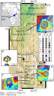


Comments